Matale stands as a captivating tapestry of natural beauty and rich cultural heritage in the heart of the lush central hills of Sri Lanka. It’s located about 25 km north of Kandy. Situated approximately 600 meters (1,969 feet) above sea level, Matale’s elevation adds a delightful touch to its climate, offering a refreshing escape from the tropical heat that characterizes much of Sri Lanka. The city’s geography, surrounded by rolling hills and verdant landscapes, provides a picturesque setting that beckons exploration. Beyond its geographical allure, Matale is a cultural gem, boasting about a history that dates back centuries. Matale’s cultural significance is further exemplified by its religious landmarks, including ancient temples and shrines that narrate tales of devotion and spirituality. Matale bares well-known UNESCO listed cultural world heritage sites; Dambulla Golden Temple and Sigiriya Rock Fortress. The Knuckles Mountain Range, a UNESCO World Heritage site, stands as a testament to Matale’s commitment to preserving its ecological treasures. Hiking trails wind through mist-covered peaks, offering breathtaking panoramas and a chance to immerse oneself in the unspoiled beauty of Matale’s highlands.
Visitors can explore the bustling markets where local artisans showcase their crafts, offering a chance to witness the intricate artistry that defines Matale’s cultural identity. Spice gardens, scattered throughout the region, beckon tourists to indulge in the fragrant world of Sri Lanka’s spices, providing a sensory experience that reflects the nation’s historical spice trade. This city invites travelers to embark on a journey that transcends the ordinary, promising an immersive encounter with the soul of Sri Lanka.
Matale is a vibrant town in Sri Lanka’s central highlands, known for its rich history, spice plantations, and proximity to some of the country’s most significant cultural landmarks. A key reason to visit Matale is its historical and natural attractions, including the famous Aluvihara Rock Temple, where ancient Buddhist scriptures were first written down. The town’s picturesque surroundings, with lush green hills and spice gardens, make it a unique destination for those interested in both culture and nature.
Matale is renowned for its spice industry, offering visitors the chance to explore spice gardens that showcase the cultivation of cinnamon, pepper, and cardamom. The area is also home to Sembuwatta Lake, a peaceful spot ideal for boating and hiking, while the nearby Knuckles Mountain Range, a UNESCO World Heritage site, is perfect for trekking and wildlife observation. Matale’s fresh produce and local dishes, such as traditional rice and curry, provide an authentic taste of the region’s culinary heritage.
The town’s central location makes it a convenient base for exploring Sri Lanka’s Cultural Triangle, with easy access to notable sites like Dambulla, Sigiriya, and Kandy. Matale combines natural beauty with cultural experiences, featuring attractions such as spice gardens, tea plantations, and waterfalls like Sera Ella, Hunnasgiriya, and Bambarakiri Ella, all contributing to its scenic charm. The rugged mountains and lush landscapes surrounding the town further add to its appeal for nature lovers.
Matale also boasts rich historical significance, with landmarks such as Lion Rock, Aluvihare Rock Temple, Sri Muthu Mariamman Thevasthanam, and Christ Church reflecting its diverse past. The old town, once reminiscent of British colonial influence, has evolved with a distinctly Sri Lankan identity. The warm hospitality of the locals, paired with simple yet flavorful home-style meals, creates a welcoming environment, making Matale a comforting retreat for visitors.
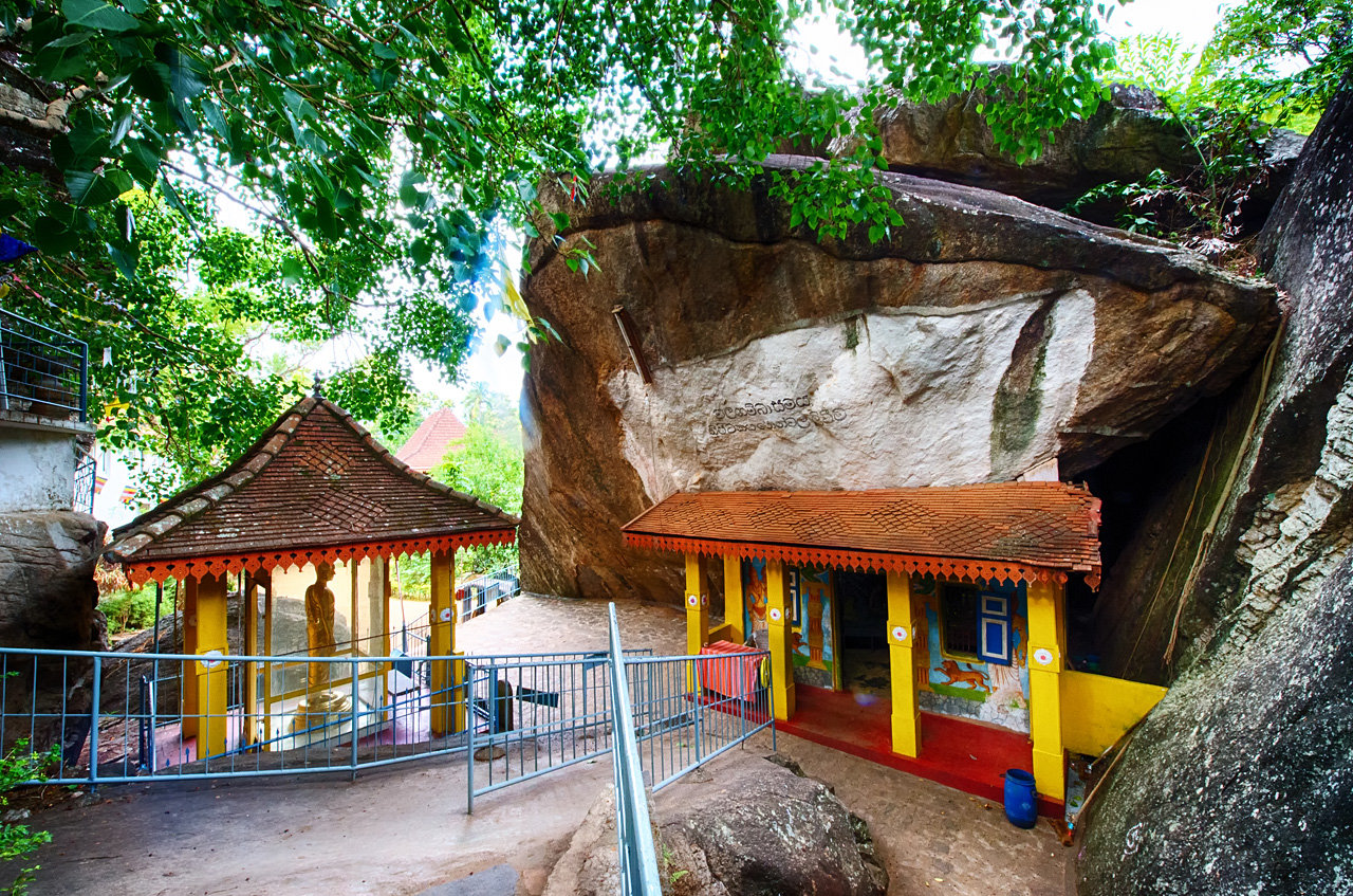
The Aluvihare Rock Temple is also called Matale Alu Viharaya. It is a sacred Buddhist temple situated in Aluvihare, Matale District of Sri Lanka. Surrounded by hills, the gorgeous Aluvihara cave is located 30 kilometers north of Kandy on the Matale-Dambulla road.
The history of Aluvihare Rock Temple goes back to the 3rd Century B.C. It was during the rule of King Devanampiyatissa. The King was the one who built the dagoba, the Aluvihare. He also planted a Bo sapling and founded the temple after the introduction of Buddhism to the country during his rule. The temple has many caves, stupas and religious paintings.
History says the temple is of great historical importance. During the invasion of Sri Lanka, the old monks considered this temple to be the safest place to transcribe the various doctrines of Buddhism. The old library of Aluvihare Rock Temple is the one that had safely housed the volumes of these transcribed manuscripts for many centuries. This old library was destroyed during the Matale Rebellion in 1848. Many parts of the temple complex were damaged too by this incident. The aftereffects of this tragedy are still quite evident at the temple grounds.
Sembuwatta Lake is a beautiful attraction point located within the village of Elkaduwa in Matale district of Sri Lanka. A quiet and ravishing human-made lake made up of natural spring water, Sembuwatta Lake is adjacent to the Campbell’s Lane Forest Reserve.
Sembuwatta Lake also has a natural swimming pool by its side. The lake processes electricity for the many villages in the area making it a lifeline for the locals as well as a pleasing addition to the long list of attractions within Sri Lanka. The Sembuwatta Lake has beautiful pine trees, situated on top of the mountain, and it is an epitome of majestic experience, which is a well-known spot for picnics, hiking, and nature trails. Sembuwatta Lake is around 30 to 39 feet deep.
The quiet and serene Lake of Sembuwatta provides an opportunity to explore many things, including photography of the beautiful lake, hiking, and nature trails. Sembuwatta Lake is one of the most beautiful attractions created by man and accompanied by beauty. This place thus deserves a must-visit from those nature lovers.
The National Spice Garden located in Matale has an Information Center as well as a Sales Center where visitors can learn about the plants and buy spices respectively. Some of the spices available for sale here are cinnamon, nutmeg, clove, ginger and pepper vines. The herbal brew they serve here is a must-try.
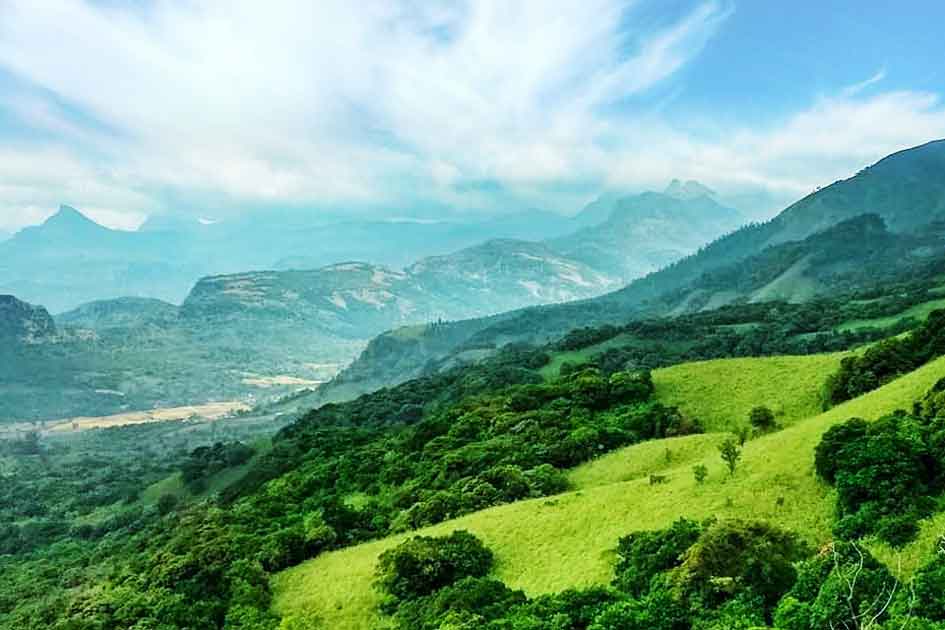
Knuckles Mountain range is an unusual terrestrial landform in Matale and Kandy, Central Province. The range is a World Heritage Conservation Area and is relatively untouched. The range features 34 peaks, ranging from 900 meters to 2000 meters. Five of these mountain peaks make the formation of a clenched fist.
The name was given by the British, and the locals call this range ‘Dumbara Kanduvetiya’, which means mist-laden mountains. The knuckles Mountain Range is called so because of its uncanny resemblance to the fingers of a clenched fist. The range, with its grasslands, rugged peaks, meandering roads and cascading streams and waterfalls are a vibrant biodiversity zone. Despite being only 0.03% of the country’s area, this zone consists of 34% of Sri Lanka’s endemic vegetation. The forest cover of the region includes dry evergreen forests, montane forests, sub-montane forests, dry and wet savanna etc.
The range faces two significant threats: constant cultivation of cardamom has deprived the forest of its vegetation cover, and a plant species called Mist Flower, which spreads into the woods and destroys the vegetation. However, there are some local and global initiatives to preserve and restore the cover. Currently, watershed conservation and restoration projects are being undertaken here full-fledged. The weather in these mountains is unpredictable. However, experts suggest that the months from December to September are safe for hiking, while October and November are the months of heavy rainfall.
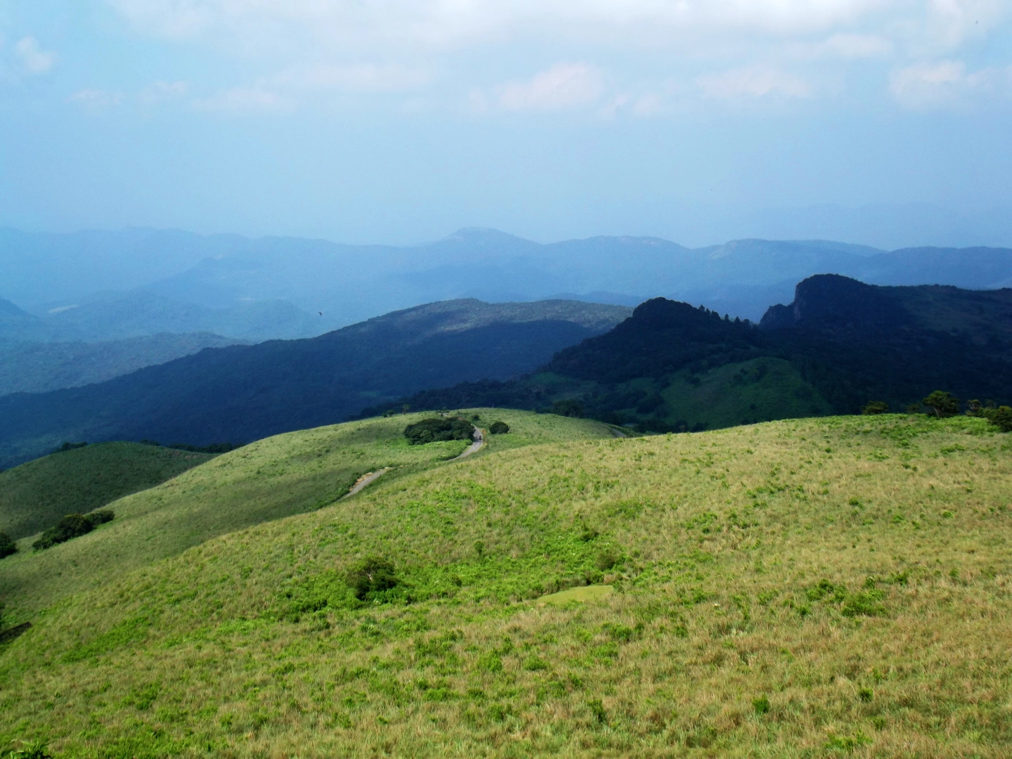
Pitawala ‘Pathana’ is a grassland located in the Matale district. It is more famously known for its resemblance to World’s End in the Horton Plains National Park. It is a part of the Knuckles Conservation Forest located in the central province.
This grassland provides an overwhelming view of the valleys and the Knuckles Mountain range. Pitawala Pathana also has significant ecological value and a host to a wide range of endemic species.
Pitawala Pathana is a distinctive grassland, spread over a vast area covering about 10 ha of the sloping rock slab. Pitawala Pathana offers a wholesome package of beautiful velvety grass landscapes, breathtaking views of the mountains and a close encounter with endemic species.
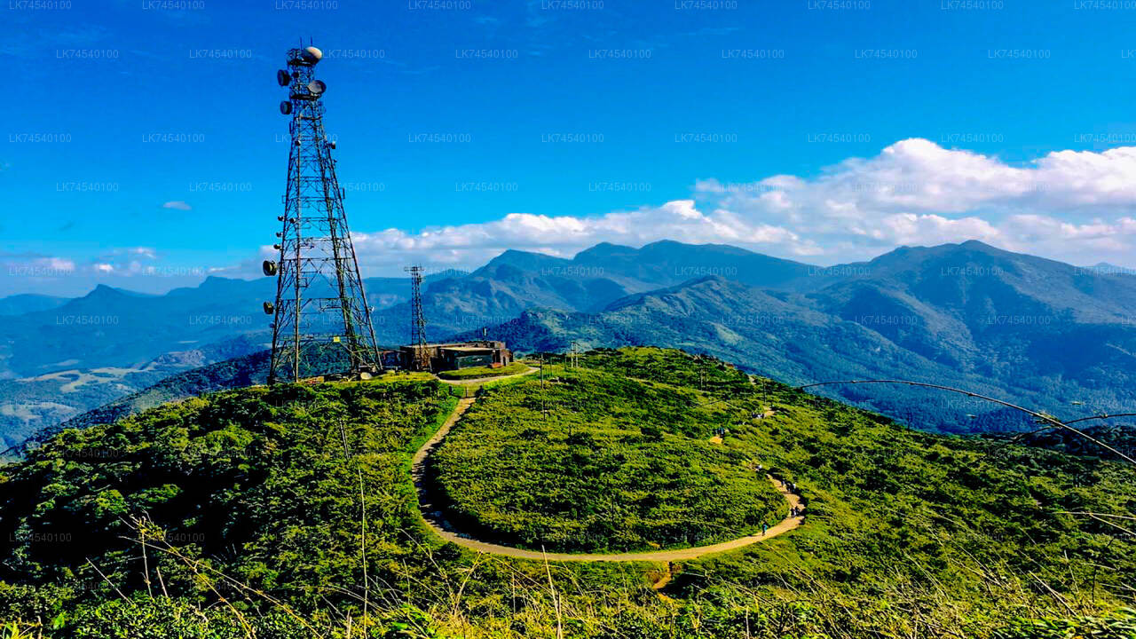
Riverston is another peak in the Knuckles Mountain range situated in Matale, Central Province of Sri Lanka. The Riverston peak has an elevation of 1,424 meters, and Riverston is a famous mountain for hiking, although not much known among foreigners. This mountain has many best views, and the mountain is located close to Pitawala Pathana Mini World’s End.
The Riverston Peak can be reached by traveling, about 30 km away from the Matale town, along the Matale – Hettipola Road via Illukkumbura. The hike in Riverston peak begins at the Matale Hettipola road after 27KM from Matale. From the base, there is a well-paved uphill road towards the left till you reach the Riverston Towers.
Compared to other mountain peaks in the Knuckles Mountain Range, the weather conditions of Riverston are well manageable as the climate is usually not very cool as this mountain is much closer to the dry zone of Knuckles. But in the rainy season & cold months, the wind speed and mist will cover the whole area and suddenly turn into a very cold place. Especially in the Riverstone gap, it is an area with lots of gusty winds, and you feel like you are being carried away.
The hike to the summit would be about 2 km long. The trail path leading to the summit is usually windy. To get the whole experience, you need to climb the Riverstone SLT Tower Mountain. This is where everyone goes to feel the ‘breeze’. The climb is a paved road, so you don’t need hiking gear or even hiking shoes. You can walk even with slippers. If you’re fit, it will take only about 15-20 minutes. If not, it is still only about 30-45 minutes maximum. There are some shortcuts through the forest as well, but it is recommend going on pave road.
Meemure is an isolated village in the Central Province of Sri Lanka, located 324m above sea level and hidden amongst the mountains. The only way to reach it is from the ‘Hunnasgiriya’ mountain, which is part of the Knuckles range, approximately 50km from Kandy. It’s a difficult trail of 33km from Hunnasgiriya to Meemure with many tricky spots, though the view along it is excellent. The village itself receives abundant water in the form of waterfalls that have their sources in the evergreen forests of the Knuckles. East of the village lies the pyramid shaped Lakegala mountain, while the west is dominated by the picturesque Knuckles range. The northern boundary of Meemure borders a forest which runs to the ‘Pitawala Pathana’ grassland; and the south is bounded by Heen River.
Pack bulls used to be the solitary method of transport to Meemure until 2004. Herds of cattle carried sacks full of goods and equipment to the village. Due to the fertility and prosperity of the village, the pack bulls were only used to carry salt, cloths, tobacco and calcium bicarbonate. But with the invasion of modern technology, the trails have been widened to allow three wheelers, jeeps and small trucks.
Meemure received its name from the ‘Mee’ trees (as the villagers called them) that surrounded the place.
According to the folklore the village dates to almost 5000 years ago. Lakegala that that lies to the east is believed to have been the property of the legendary King Ravana from the Indian literary epic Ramayana. As the stories go, Lakegala was used by Ravana as a power source and there was a tunnel through Lakegala in the times of Ramayana. It is said the tunnel was sealed after the war of Ramayana with the corpse of Ravana placed within it.
Another story states dates to 700 B.C which was the era of King Vijaya who is believed to be the forefather of the current population of Sri Lanka. Vijaya arrived on the island from India with his followers and caught sight of the shapely primitive woman Kuweni. He was overtaken by lust and took Kuweni as his informal wife. Kuweni bore him two children, but then Vijaya banished her from his castle when he formally married a royal princess from India. Hence Kuweni was forced to take her move into the forest along with her children. It is believed that they lived in the forest where Meemure is located, and that the indigenous people of Sri Lanka originated from the two children of Kuweni. The indigenous people of modern Sri Lanka are based just 60km from Meemure in Mahiyanganaya; and seem to prove this belief to be the truth.
During the 16th century AD Sri Lanka was invaded by Portugal. The invasions continued through the centuries as the Dutch and English nations conquered the country subsequently. The annals of history state that the people of Meemure supplied saltpeter (potassium nitrate) for the gunpowder used by the Kandyan kingdom in their efforts of resistance. The cave that the saltpeter was (niter) was mined from still exists to this day.
During the same era, King Sri Wickrama Rajasinghe is said to have banished his daughter with a group man, one of whom he believed his daughter was having an affair with, to the village of Meemure. This solidifies the claim that Meemure in existence at the time.
The village has a population of approximately 400 with about 125 families. The architecture is one of the main identities of Meemure. The villagers build eco-friendly homes using clay and illuk (spear grass) which lasts for over three decades. But the most unique aspect of their buildings is their boundary walls made of quartz.
Before cardamom cultivation was banned in 1982 due to the Forest Preservation Act, Meemure villagers earned their bread by harvesting the spice. After this they shifted to chena cultivation, paddy cultivation and pepper cultivation.
Nowadays some of the peasants earn their living by taking care of jaggery palms, which produce toddy and treacle. The village has one tiny village shop where the locals buy necessities such as salt and sugar; and no cable telephone or mobile network signal. The village does have CDMA telephone services, though, to some extent.
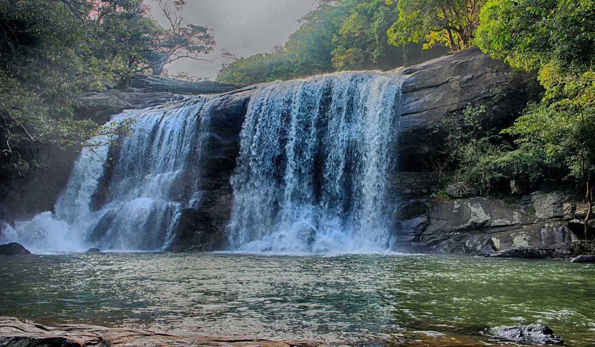
The beautiful Bambarakiri Ella waterfalls are within the Matale district of the central province, near the Rattota town. The falls are mighty and at the same time, pleasant. Two falls subside here. A small fall is hidden inside the jungle and is named ‘Kuda Bambarakiri Ella’ where ‘Kuda’ implies ‘little’. The primary falls allow tourists to sit peacefully and enjoy the sound of splashing water.
A rope bridge also exists which stretches over the falls is an excellent addition to the scenic beauty. The falls are an alluring sight for clicking perfect wallpaper pictures; however, safety comes first as the Bambarakiri Ella falls are not safe for swimming and bathing. The falls are divided within three cascades, that is the tallest slope, the natural pool and the slope at the edge of the natural one, which is a rocky point. Bambarakiri Ella is an ideal place to visit while in Sri Lanka.

